Thursday, 23 August 2018

Gorakh Hill Station

Gorakh (Sindhi: گورک‎), (Urdu: گورکھ‎)

 is a Hill Station of Sindh, Pakistan. It is situated at an elevation of 5,689 ft (1,734 m) in the Kirthar Mountains, 94 kilometres (58 mi) northwest of Dadu city.

Did you know that the province of Sindh has its own hill station? All you have to do is travel to Dadu to see it. It is Sindh’s highest point and lies on the border of Sindh and Balochistan.

Although the roads to this place are in poor condition, when one reaches
Gorakh Hill Station, the journey becomes worth it.

 The Gorakh Hill station is situated 423 km from Karachi and nearly 8 hours driving distance. The Hill station attracts thousands of tourists from the city.

The name Gorakh is derived from the Brahvi language in which, word "Gurgh" means Wolf and that Balochi language word "Gurkh" is later dialectic adaptation of Brahvi language word Gurgh, meaning
wolf.

Gorakh Hill Station is situated on one of the highest plateaus of Sindh, spread over 2,500 acres (10 km2) of land. It is very attractive to nature-lovers owing to its temperate weather and beautiful surroundings. 

Different opinions have been given about the history and origin of the hill station. It is said that the great
medieval Hindu saint, Sri Gorakhnath Ji, had extensively wandered in hills and the region.

According to Nandu, an authority on Sanskrit, Gorakh is a Sanskrit word which means "shepherding of sheep, cow and goat, etc.

Wednesday, 22 August 2018

Shandur Top

Shandur Pass (Urdu: شندور‎)

is located between Chitral District and Ghizer District of Gilgit-Baltistan in North Pakistan as a common shared pass. It is often called the 'Roof of the World'.

The top is flat, a plateau and can be crossed between late April and early November. The grade is very gradual, and the area is crossed by plentiful small streams during summer. The boundary line between Chitral District and Ghizer District of Baltistan.

During the annual 'Shandur Polo Festival,' which is organized Chitral Districts and Ministry of tourism Gilgit-Baltistan, there is a polo match being played on Shandur Top, between the teams of Chitral District and districts of Gilgit-Baltistan.

The Shandur Pass is one of the major mountain passes between of Chitral District and Ghizer
District of Baltistan, Pakistan.

The initiation of Polo in Shandur is credited to The balti raja of Skardu; Ali Sher Khan Anchan who built the polo ground of Shandur as well.Shandur invites visitors to experience a traditional polo tournament which since 1936 has been held annually in the first week of July between the local teams of Gilgit and Chitral. Organized and financed by the Tourism Corporation of NWFP,

The tournament is held on Shandur Top, the highest polo ground in the world at 3,700 meters (the pass itself is at 3,800 meters). The festival also includes Folk music, dancing and a camping village is set up. The polo tournament is featured in the first episode of Himalaya with Michael Palin

Historically, polo being the king of games was played between small kingdoms, villages and rival groups of Gilgit Agency. From 1936 onwards polo tournaments were held annually at Shandur at the patronage of the British.

The three-day Shandur Polo Festival has developed steadily in recent years into the massive celebration of mountain polo that it is today.

Located in Khyber-Pakhtunkhwa’s Chitral area, Shandur Top is thought to be the highest polo ground in the world. Although snow keeps the place covered in snow in winter, Shandur Top turns into a lush green scenery in summer. Every July, Shandur Polo Festival is held here and is an attraction to tourists and natives. It is difficult to get here in winters considering the heavy snowfall and slippery tracks, but in summers visitors use jeeps to reach it.
.

Tuesday, 21 August 2018

Kalash Valley

The Kalasha Valleys
(Kalasha-mondr: Kaĺaśa Desh; Urdu: وادی کالاش‎)
 are valleys in Chitral District in northern Pakistan. The valleys are surrounded by the Hindu Kush mountain range. The inhabitants of the valley are the Kalash people, who have a unique culture, language and follow a form of ancient Hinduism.As such, the Kalasha Valleys are a source of attraction for Pakistani as well as International tourists.

There are three main valleys. The largest and most populous valley is Bumburet (Mumuret), reached by a road from Ayun in the Kunar Valley. Rumbur and Acholgah are side valleys north of Bumburet. The third valley, Biriu (Birir), is s side valley of the Kunar Valley south of Bumburet.

Kalash people are the smallest religious as well as the ethnic minority of Pakistan. Their customs and traditions are contradictory to the Islamic and
Pakistani culture. The Kalash religion is polytheist faith and the people offer sacrifices for their gods. Their culture is interlinked with their religion and based upon several festivals and celebrations. The people generally do not intermarry or cohabit regions with local Muslims but neither are they hostile towards them. The people are under legal and constitutional protection of the State of Pakistan as a scheduled tribe.

Resting in the Chitral District, this heaven is home to the Kalasha tribe. They construct their homes with logs on the hill sides. The valley is not only famous for its beauty but also the colorful lifestyle, cult ure and festivals.

Tuesday, 31 July 2018

Wazir Khan Mosque

The Wazir Khan Mosque
(Punjabi and Urdu: مسجد وزیر خان ‎; Masjid Wazīr Khān)

is 17th century mosque located in the city of Lahore, capital of the Pakistani province of Punjab. The mosque was commissioned during the reign of the Mughal Emperor Shah Jahan as part of an ensemble of buildings that also included the nearby Shahi Hammam baths. Construction of Wazir Khan Mosque began in 1634 C.E., and was completed in 1641.

Considered to be the most ornately decorated Mughal-era mosque, Wazir Khan Mosque is renowned for its intricate faience tile work known as kashi-kari, as well as its interior surfaces that are almost entirely embellished with elaborate Mughal-era frescoes.

The mosque is located in the Walled City of Lahore along the southern side of Lahore's Shahi Guzargah, or "Royal Road," which was the traditional route traversed by Mughal nobles on their way to royal residences at the Lahore Fort.


The mosque is situated approximately 260 metres west of the Delhi Gate, where the mosque's Shahi Hammam is located. The mosque also faces a town square known as Wazir Khan Chowk, and the Chitta Gate.

Monday, 30 July 2018

Deosai National Park

The Deosai National Park
(Urduدیوسائی نیشنل پارک‎) 


is a high-altitude alpine plain and national park in northern Pakistan. It is located largely within Skardu  in Gilgit Baltistan. Deosai Plains are situated at an average elevation of 4,114 metres (13,497 ft) above sea level.


The Deosai National Park is located between KharmangAstore and Skardu in Gilgit Baltistan. It has an average elevation of 4,114 metres (13,497 ft) above sea level, making the Deosai Plains one of the highest plateaus in the world. The park protects an area of 3,000 square kilometres (1,200 sq mi).


It is well known for its rich flora and fauna of the Karakoram-West Tibetan Plateau alpine steppe eco region. In spring, it is covered by sweeps of wildflowers and a wide variety of butterflies. Deosai is second highest plateau after Chang Thang Plateau Tibet.


Deosai is accessible from Skardu District in the north, Galtari Kharmang District in the south-east, and the Astore District in the west. Deosai is located approximately 30 km from Skardu city and it is the shortest route to visit Deosai. Most foreigners visit Deosai via Skardu

It takes 1 hour to reach Deosai top via Sadpara Skardu. Another route is from Astore valley via Chilim. It is also accessible from Shila valley. The people of Galtari travel via Deosai. There is another route called Burgi la via Tsoq Kachura valley Skardu.

AAAAAA

Friday, 27 July 2018

Concordia

Concordia
(Urdu: کونکورڈیا‎)
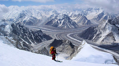
IS the name for the confluence of the mighty Baltoro Glacier and the Godwin-Austen Glacier, in the heart of the Karakoram range of Pakistan. It is located in Baltistan region of Pakistan. The name was applied by European explorers, and comes from this location's similarity to a glacial confluence, also named Concordia, in the Bernese Oberland, part of the Central Alps.
Around Concordia are clustered some of the highest peaks in the world. Four of the world's fourteen "eight-thousanders" are in this region, as well as a number of important lower peaks.

Concordia offers the region's best place to camp for mountain enthusiasts not involved in climbing. With scenic views, it also offers short treks to several important base camps: K2 (5–6 hours), Broad Peak (2–3 hours) and the Gasherbrum I&II (7–8 hours). An alternative exit to returning down the Baltoro Glacier is available by climbing the Gondogoro Pass (5615 meters). Visitors to the region are advised to carefully monitor their water intake with concern. To avoid often painful and sometimes debilitating stomach upsets at high altitude, water should be obtained from clear water sources and brought to a rolling boil, or purified before consumption.

Concordia: This Mountaineers paradise is located in the extreme north of Pakistan along the borders of China. Pakistan bears five of the tallest 14 mountain peaks of the world, and four of these can be seen from Concordia.


Thursday, 26 July 2018

Saiful Muluk

Saiful Muluk
(Urdu: جھیل سیف الملوک‎) is a mountainous lake located at the northern end of the
Kaghan Valley, near the town of Naran in the Saiful Muluk National Park. The lake is a source of the Kunhar river. At an elevation of 3,224 m (10,578 feet) above sea level, the lake is located above the tree line, and is one of the highest lakes in Pakistan.


Lake Saif-ul-Malook: This beauty is located at the northern end of Kaghan Valley. It is in the north-east of Mansehra Division of the Khyber-Pakhtunkhwa province. Not only the mountains surrounding it make the place beautiful, but its reflection in the lake is definitely breathtaking! Summers are a good time to go here using the jeeps. However, in winter, it can take quite long to get here and sometimes the jeeps aren’t a good option considering slippery paths.
Saiful Muluk is located in the Mansehra district of Khyber Pakhtunkhwa, about 9 kilometers (5.6 mi) north of Naran, in the northern part of Kaghan Valley. Malika Parbat, the highest peak in the valley is near the lake.
The lake is accessible from the nearby town of Naran during the summer season but access during winter is limited.