Tuesday 31 July 2018

Wazir Khan Mosque

The Wazir Khan Mosque
(Punjabi and Urdu: مسجد وزیر خان ‎; Masjid Wazīr Khān)

is 17th century mosque located in the city of Lahore, capital of the Pakistani province of Punjab. The mosque was commissioned during the reign of the Mughal Emperor Shah Jahan as part of an ensemble of buildings that also included the nearby Shahi Hammam baths. Construction of Wazir Khan Mosque began in 1634 C.E., and was completed in 1641.

Considered to be the most ornately decorated Mughal-era mosque, Wazir Khan Mosque is renowned for its intricate faience tile work known as kashi-kari, as well as its interior surfaces that are almost entirely embellished with elaborate Mughal-era frescoes.

The mosque is located in the Walled City of Lahore along the southern side of Lahore's Shahi Guzargah, or "Royal Road," which was the traditional route traversed by Mughal nobles on their way to royal residences at the Lahore Fort.


The mosque is situated approximately 260 metres west of the Delhi Gate, where the mosque's Shahi Hammam is located. The mosque also faces a town square known as Wazir Khan Chowk, and the Chitta Gate.

Monday 30 July 2018

Deosai National Park

The Deosai National Park
(Urduدیوسائی نیشنل پارک‎) 


is a high-altitude alpine plain and national park in northern Pakistan. It is located largely within Skardu  in Gilgit Baltistan. Deosai Plains are situated at an average elevation of 4,114 metres (13,497 ft) above sea level.


The Deosai National Park is located between KharmangAstore and Skardu in Gilgit Baltistan. It has an average elevation of 4,114 metres (13,497 ft) above sea level, making the Deosai Plains one of the highest plateaus in the world. The park protects an area of 3,000 square kilometres (1,200 sq mi).


It is well known for its rich flora and fauna of the Karakoram-West Tibetan Plateau alpine steppe eco region. In spring, it is covered by sweeps of wildflowers and a wide variety of butterflies. Deosai is second highest plateau after Chang Thang Plateau Tibet.


Deosai is accessible from Skardu District in the north, Galtari Kharmang District in the south-east, and the Astore District in the west. Deosai is located approximately 30 km from Skardu city and it is the shortest route to visit Deosai. Most foreigners visit Deosai via Skardu

It takes 1 hour to reach Deosai top via Sadpara Skardu. Another route is from Astore valley via Chilim. It is also accessible from Shila valley. The people of Galtari travel via Deosai. There is another route called Burgi la via Tsoq Kachura valley Skardu.

AAAAAA

Friday 27 July 2018

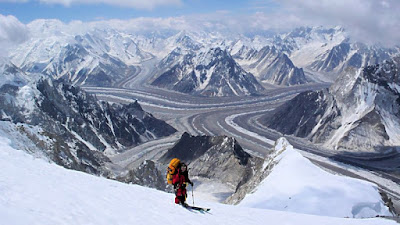
Concordia

Concordia
(Urdu: کونکورڈیا‎)
IS the name for the confluence of the mighty Baltoro Glacier and the Godwin-Austen Glacier, in the heart of the Karakoram range of Pakistan. It is located in Baltistan region of Pakistan. The name was applied by European explorers, and comes from this location's similarity to a glacial confluence, also named Concordia, in the Bernese Oberland, part of the Central Alps.
Around Concordia are clustered some of the highest peaks in the world. Four of the world's fourteen "eight-thousanders" are in this region, as well as a number of important lower peaks.

Concordia offers the region's best place to camp for mountain enthusiasts not involved in climbing. With scenic views, it also offers short treks to several important base camps: K2 (5–6 hours), Broad Peak (2–3 hours) and the Gasherbrum I&II (7–8 hours). An alternative exit to returning down the Baltoro Glacier is available by climbing the Gondogoro Pass (5615 meters). Visitors to the region are advised to carefully monitor their water intake with concern. To avoid often painful and sometimes debilitating stomach upsets at high altitude, water should be obtained from clear water sources and brought to a rolling boil, or purified before consumption.

Concordia: This Mountaineers paradise is located in the extreme north of Pakistan along the borders of China. Pakistan bears five of the tallest 14 mountain peaks of the world, and four of these can be seen from Concordia.


Thursday 26 July 2018

Saiful Muluk

Saiful Muluk
(Urdu: جھیل سیف الملوک‎) is a mountainous lake located at the northern end of the
Kaghan Valley, near the town of Naran in the Saiful Muluk National Park. The lake is a source of the Kunhar river. At an elevation of 3,224 m (10,578 feet) above sea level, the lake is located above the tree line, and is one of the highest lakes in Pakistan.


Lake Saif-ul-Malook: This beauty is located at the northern end of Kaghan Valley. It is in the north-east of Mansehra Division of the Khyber-Pakhtunkhwa province. Not only the mountains surrounding it make the place beautiful, but its reflection in the lake is definitely breathtaking! Summers are a good time to go here using the jeeps. However, in winter, it can take quite long to get here and sometimes the jeeps aren’t a good option considering slippery paths.
Saiful Muluk is located in the Mansehra district of Khyber Pakhtunkhwa, about 9 kilometers (5.6 mi) north of Naran, in the northern part of Kaghan Valley. Malika Parbat, the highest peak in the valley is near the lake.
The lake is accessible from the nearby town of Naran during the summer season but access during winter is limited.