Sunday 20 September 2015

The Karakoram Highway

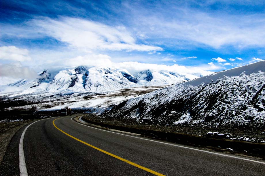
The Karakoram Highway(KKH) is one of the highest paved international roads in the world.


The Karakoram Highway (often abbreviated to KKH and sometimes transliterated as Karakorum) runs between Western China and Pakistan . It is one of the very few routes that cross the Himalayas and the most westerly of them. Following the KKH is considered to be one of the classic journeys of the travel world, it is also the highest international road in the World.

Historically, this was a caravan trail, one branch of the ancient Silk Road. More recently, the Chinese and Pakistani governments have built a highway.
It is the highest border crossing in the world, over 4800 meters (roughly 16,000 feet) in the Khunjerab Pass at the border. For comparison, Mont Blanc, the tallest mountain in Western Europe, is 4810 m and Mount Whitney, the highest point in the 48 contiguous United States, is 4421.


It may be the ultimate challenge for the devoted cyclist. There are organised bicycle tours, and several books about bicycling this route. Unfortunately the border is not open for cyclists. Everybody has to board the bus in either Tashkurgan (China) or Sost (Pakistan). From the Pakistani side you CAN cycle up to the pass, but not over it. You will have to return to Sost to take the bus.


Choose your time carefully. The highway is open around the year, though the tourist time is usually from May till late November and beware closures on religious or public holidays. It's a tough terrain and expect landslides during rainy season. Road condition is very good as the governments of Pakistan and China have reconstructed the highway. It is not advisable to take cars, 4x4 is preferred but a Van / coaster would serve the purpose. Besham is the start of Kohistan which is famous for its ruggedness and stubbornness. It is highly advisable to limit your stay and keep going preferably during day time. Kohistan borders Baltistan which is relatively safe. Main town to stay overnight is Chilas.
The KKH section from Besham to Gilgit is dry and warm. In summers, the temperature may go as high as 40 Celcius (Chillas is known as Sibi of Baltistan). Keep yourself well hydrated.

As of July 2013, there are two police checkpoints along the highway in China; for those leaving Kashgar, the smaller one is before Karakol Lake, and a larger one before Tashkurgan. These may slow down your journey significantly if there are many cars and trucks.


The Pakistani section of the highway officially starts from Hasan Abdal, 60 kms from Islamabad. Chinese section starts from Kashgar, a major city in Xinjiang Autonomous Region , 1479 kms from Urumqi.


The highway passes the Hunza Valley The Hunza was the original Shangri La that inspired the novel (and later movie). Hunza is known for its orchards, moderate Islam, welcoming hospitality and beautiful scenery.


You can see in your way ............
  • Baltit & Altit Forts


  • Uprising Memorial is a memorial dedicated to the people of Kashmir Valley who rose against Maharaja in 1947. It includes the graves of the local heroes, Mohammed Babar Khan and Safiullah Beg of the Gilgit Scouts, and Mirza Hassan Khan of the Kashmir Infantry.


  • Ganish Village: The Village has been recenly restored
    and had already won a UNESCO Asia Pacific Heritage Award. Located in Hunza, Ganish shows traditional Hunza life. It includes several richly carved wooden mosques, 100 to 200 years old. Near to Ganish Village is Gulmit which is popular for Hunza's Mir Palace, a Cultural Museum and Marco Polo cafe. Also see Sacred Rocks of Hunza.
  • Channel Walk: A three- or four-hour walk along the main water channels from Ultar Nala is a good way to see Hunza at its best. Try to avoid the delicate side channels.


  • Queen Victoria Monument: The Queen Victoria Monument at the top of the rock face behind Karimabad can be reached in an hour from Baltit.


  • Ashoka Rocks: On the north side of town is Mansehra's tourist attraction, three granite boulders on which 14 edicts were engraved by order of the Mauryan king Ashoka in the 3rd century BC.


  • Italian K2 Museum: Located at PTDC K2 Motel, the museum was setup in 2004 to commemorate Italian expedition of K2 in 1954.


  • Kharpochu Fort 


  • Shigar Fort 


  • Khaplu Palace


Pakistan is one of the most peaceful region in the World so the travellers do not need to worry about the security there, you are free to go anywhere, Just avoid drinking the tap water use mineral water, If you are in upper Hunza (Gojal)then you can drink the tap water, its clear and it comes directly from the spring!  
Have a nice journey..........

Wednesday 9 September 2015

Gwadar

Gwadar (Balochi: گوادر Gwadur) is a city on the southwestern Arabian Sea coastline of Pakistan, in Balochistan province. Under development as a free trade port, it is the district headquarters of Gwadar District and, in 2011, was designated the winter capital of Balochistan province.It is situated nearly to Persian gulf countries,Eastern European countries Armenia,Geogia,Azerbaijan and western asian countries Iran and Turkey.


Gwadar is 0–300 meters above sea level and is mainly dry, arid and hot. The oceanic influence keeps the temperature lower in summer and higher in winter as compared to the inland. The mean temperature in the hottest month (June) remains between 31 °C and 32 °C. The mean temperature in the coolest month (January) varies from 18 °C to 19 °C. The uniformity of temperature is a unique characteristic of the Makran Coastal region. Occasionally, winds moving down the Balochistan plateau bring brief cold spells, otherwise the winter is pleasant. In Gwadar, winters are shorter than summers. Although Gwadar is situated outside the monsoon belt, it receives light monsoon showers in summer (June–August). However, in winter, Western Disturbance can cause heavy rainfall. Annual rainfall is only 100 mm (3 inches). In June 2010, Gwadar was lashed by Cyclone Phet with record-breaking rains of 372 mm and winds up to 75 mph.

Gwadar Port is a warm-water, deep-sea port situated on the Arabian Sea at Gwadar in Balochistan province of Pakistan. The port is a major destination in the China–Pakistan Economic Corridor.
Pakistan identified Gwadar as a port site as far back as 1954 when Gwadar was still under Omani rule. Pakistan's interest in Gwadar started when, in 1954, it engaged the United States Geological Survey (USGS) to conduct a survey of its coastline. The USGS deputed the surveyor, Worth Condrick, for the survey, who identified Gwadar as a suitable site for a seaport. After four years of negotiations, Pakistan purchased the Gwadar enclave from Oman for $3 million on 8 September 1958 and Gwadar officially became part of Pakistan on 8 December 1958, after 200 years of Omani rule. At the time, Gwadar was a small and underdeveloped fishing village with a population of a few thousand.

Gwadar is located on the shores of the Arabian Sea it is in Pakistan's western province of Balochistan. It is about 533 km from Karachi and 120 km from the Iranian border and 380 km (240 mi) km northeast of the nearest point in Oman across the Arabian Sea. Gwadar Port is located at the mouth of the Persian Gulf, just outside the Strait of Hormuz, near the key shipping routes in and out of the Persian Gulf. It is situated on the eastern bay of a natural hammerhead-shaped Peninsula protruding into the Arabian Sea from the coastline.
The surrounding region is home to around two-thirds of the world's oil reserves. It is also the nearest warm-water seaport to the landlocked, but energy rich, Central Asian Republics and landlocked Afghanistan.

Gwadar being a relatively a small town and in the process of being developed, especially with a modern port, offers lot of opportunities to prospective investors amongst others some of them are in the following fields: Port related infrastructure such as storage, warehousing etc. Hotels, Motels, travel and tourism. Industrial sector, i.e. sea food processing and export, date processing and export construction – office spaces etc. Social sector and other. Infrastructure Projects. Telecommunication, road, network extension of airport, railways, special economic zone.

Gwadar is strategically located on the western end of Baluchistan coast on the opposite end of the Gulf of Oman which is an important route for oil tankers bound for Japan and western countries out of Gulf. Since outflow of goods from western China and Central Asia reaching Gwadar will pass through this overland trade route, Pakistan could earn millions of dollars a year in terms of port and cargo handling charges and also as freight charges for import cargoes and export goods. According to Arthur D. Little (Malaysia), the main consultant firm of the Gwadar development phases, low-cost land and labour are available, there is proximity to oil and gas resources and Gulf countries, there are some agricultural and mineral resources, while there could be tax-free status for investments and trade. The Gwadar Port is expected to generate billions of dollars in revenues and create at least two million jobs.
Gwadar has the potential to acquire the status of a centerpiece as a gate to the Strait of Hormuz; it can compete with the United Arab Emirates ports by improving the exiting links to the Caspian Region, thus providing a better trade route to the landlocked Caspian Region. Gwadar has the potential to be developed into a full-fledged regional hub and a trans-shipment port in the future.

The Government of Balochistan is developing an industrial estate in Gwadar to meet the demand for industrial plots in the port city, which is expected to have substantial potential for industrial investment in view of the opportunities offered by the establishment of deep sea port and construction of major highways linking Gwadar with Karachi, Quetta, Iran and Central Asian countries. There are also plans to extend railway to Gwadar. Gwadar Industrial park will be developed for small and medium enterprises (SMEs) mostly based on value-added industries. No large manufacturing industries would be expected, except those feasible on imported raw materials with final product to be exported. The major areas of business will be: import and export, construction, transportation, shipping, clearing and forwarding, warehousing, building material, value added processing, textile and leather made-up garments, repackaging and trans-shipment. For development and management of Gwadar Industrial Estate, an autonomous body Gwadar Industrial Estate Development Authority (GIEDA) has been established by the Government of Balochistan, which is headed by its Chairman, the Secretary Industries & Commerce, Balochistan, while other Directors of the board include Secretary Finance, Balochistan, Director Industries, Balochistan and Managing Director GIEDA. This will provide substantial executive and financial authority to GIEDA and facilitate accelerated development.

The future of Gwadar is very bright,

Sunday 6 September 2015

Gilgit

Gilgit (Urdu, Shina: گلگت) is the Capital city of Gilgit-Baltistan, an administrative territory of Pakistan.
The city of Gilgit constitutes a tehsil within Gilgit District. The city's ancient name was Sargin, later to be known as Gilit, and it is still referred to as Gilit or Sargin-Gilit by local people. In the Burushaski language, it is named Geelt and in Wakhi and Khowar it is called Gilt. Ghallata is considered its name in ancient Sanskrit literature.

Phandar Lake

Gilgit experiences a cold desert climate (Köppen climate classification . Weather conditions for Gilgit are dominated by its geographical location, a valley in a mountainous area, southwest of Karakoram range. The prevalent season of Gilgit is winter, occupying the valley eight to nine months a year.

Phandar valley Gilgit

Gilgit lacks significant rainfall, averaging in 120 to 240 millimetres (4.7 to 9.4 in) annually, as monsoon breaks against the southern range of Himalayas. Irrigation for land cultivation is obtained from the rivers, abundant with melting snow water from higher altitudes.
File:KKH.pngThe summer season is brief and hot. The piercing sunrays may raise the temperature up to 40 °C (104 °F), yet it is always cool in the shade. As a result of this extremity in the weather, landslides and avalanches are frequent in the area
Gilgit city is one of the two major hubs for all mountaineering expeditions in Gilgit–Baltistan. Almost all tourists headed for treks in Karakoram or Himalaya Ranges arrive at Gilgit first. Gilgit is served by the nearby Gilgit Airport. Many tourists choose to travel to Gilgit by air, since road travel between Islamabad and Gilgit, by the Karakoram Highway, takes 14–24 hours, whereas the air travel takes a mere 55–60 minutes.

Gilgit was an important city on the Silk Road, along which Buddhism was spread from South Asia to the rest of Asia. It is considered as a Buddhism corridor from which many Chinese monks came to Kashmir to learn and preach Buddhism.

File:Buddha at Kargah Gilgit.jpgBrogpas trace their settlement from Gilgit into the fertile villages of Ladakh through a rich corpus of hymns, songs, and folklore that have been passed down through generations. The Dards and Shinas appear in many of the old Pauranic lists of peoples who lived in the region, with the former also mentioned in Ptolemy's accounts of the region. Two famous travellers, Faxian and Xuanzang, traversed Gilgit according to their accounts.


Fairy Meadows Lake
Polo is the favourite game of the people of Gilgit, Skardu, Ghanche, Chilas, Astore, Hunza, Nagar, and the surrounding areas. Every year, many tourists visit to enjoy polo in Gilgit-Baltistan. "Polo" is a Persian word which means "ball".

Other games such as cricket, tuksori of Nagar, gulli danda, kabbadi, and volleyball are also played.
There are several tourist attractions relatively close to Gilgit: Naltar Valley with Naltar Peak, Hunza Valley, Nagar Valley, Fairy Meadow in Raikot, Shigar town, Skardu city, Haramosh Peak in Karakoram Range, Bagrot-Haramosh Valley, Deosai National Park, Astore Valley, Rama Lake, Juglot town, Phunder village, Yasin Valley, Kargah Valley and nomal, Gilgit Baltistan.


Come visit us and feel the difference...........

Friday 4 September 2015

The Capital of PAKISTAN "ISLAMABAD"


Welcome to the Capital of Pakistan. Islamabad        اسلام آباد‎, located within the Islamabad Capital Territory. It has a population of 2 million and together with its neighboring twin city of Rawalpindi, the greater Islamabad-Rawalpindi metropolitan area is the third largest in Pakistan with a population of over 4.5 million inhabitants.Islamabad is located at
33°26′N 73°02′E / 33.43°N 73.04°E at the northern edge of the Pothohar Plateau and at the foot of the Margalla Hills in Islamabad Capital Territory. Its elevation is 540 metres (1,770 ft). The modern capital and the ancient Gakhar city of Rawalpindi stand side by side and are commonly referred to as the Twin Cities, where no exact boundary exists between the two cities. To the northeast of the city lies the hill station of Murree, and to the north lies the Haripur District of Khyber Pakhtunkhwa. Kahuta lies on the southeast, Taxila, Wah Cantt, and Attock District to the northwest, Gujar Khan, Rawat, and Mandrah on the southeast, and the metropolis of Rawalpindi to the south and southwest. Islamabad is located 120 kilometres (75 mi) SSW of Muzaffarabad, 185 kilometres (115 mi) east of Peshawar, 295 kilometres (183 mi) NNE of Lahore, and 300 kilometres (190 mi) WSW of Srinagar, the capital of the Indian state of Jammu and Kashmir.
The city of Islamabad expanses an area of 906 square kilometres (350 sq mi). A further 2,717 square kilometres (1,049 sq mi) area is known as the Specified Area, with the Margala Hills in the north and northeast. The southern portion of the city is an undulating plain. It is drained by the Kurang River, on which the Rawal Dam is located. 


Islamabad, one of the most beautiful capitals of the world, famous for its beauty, decor, fascination, attractiveness and the one regarded fully. Islamabad being the glorious one could be competed over the entire cities of the world. It is highly developed and the developments can been seen in every angle of the city, moreover it is the ninth largest city in the world.. The most beautiful capital of the world is the one on which entire Pakistan feel proud and very well pleased. People thought to visit Islamabad for Islamabad being too striking, fine-looking and stunning.


It is also famous for being clean, cool, calm, peaceful, sparkling, hygienic, and fresh and dirt free. It is the most broad-based and urbanized city of the Pakistan. It is very up-to-dated one, modern and very well maintained lie at the northern part of the country capturing the beauty of northern areas of Pakistan. Islamabad is efficient, well-ordered, well planned and well-maintained city being divided into different zones and sectors each with a distinction of its own beauty. Islamabad is quite very source of amusement and a great place to spend holidays and to visit too due to its adorable beauty not only of buildings but of the green lands and parks and many more. For keeping in view all these dignified facts and figures Islamabad is enlisted in the top ten beautiful capital cities.